
The short answer
The Kallang River at Bishan–Ang Mo Kio Park can occupy a narrow stream on a dry day and a wider part of the landscape after rain. That difference is part of the design. The project joined renewal of the park to a change in how a reach of the river carries stormwater.
Reading the records
How the park changes after heavy rain
The area available to carry a flood includes more than the stream visible on a dry day.
| Design element | Dry weather | After heavy rain |
|---|---|---|
| Stream | Water stays in a narrower channel. | Water level rises. |
| Banks | Planted slopes define the edge. | Water can spread beyond its usual edge. |
| Adjacent land | Lawn and paths belong to the park. | Low ground provides room for stormwater. |
Chronology
A timeline of the turning points
Concrete canal
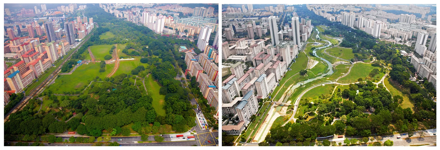
The earlier aerial photograph shows the straight-sided channel.
New alignment visible
The later aerial view shows a naturalised channel.
Park reopened
Lee Hsien Loong formally reopened the renewed park.
Why the measured length changed
PUB describes replacing a 2.7-kilometre concrete canal with about three kilometres of naturalised river. The longer measurement follows a reworked alignment. The paired aerial photographs show how straight edges gave way to bends and broader margins. The shape of the intervention is visible before the differences between individual plantings become apparent.
What the floodplain does
In dry conditions the visible stream is narrower than the space needed during heavy rain. Low ground beside the river provides room for flood flows. The same land can support recreation at normal flow and help convey water when the river rises. A photograph taken on a dry day therefore only shows part of the space the designers set aside for water.
Stabilising a planted bank
PUB and the National Parks Board tested plantings and materials for bank stabilisation. The published project brief identifies seven bioengineering techniques selected after testing. Plants formed part of an engineered edge alongside materials and methods chosen to limit erosion. The agency’s annual report dates the official reopening to 17 March 2012, after the change in channel visible in the paired photographs.
Continue the chronology
Related history guides
How Singapore Cleaned the Singapore River and Kallang Basin
Trace the earlier clean-up of the Singapore River and Kallang Basin.
Read the timeline2008–2010How Marina Barrage Made a Reservoir and Managed Floods
Compare a park floodplain with gates and pumps at the mouth of Marina Bay.
Read the timelineConnected biographies
People in this history

1952—
Lee Hsien Loong
Third Prime Minister and Senior Minister of SingaporeSingapore’s third prime minister, who led two decades of economic restructuring, social-policy expansion, digitalisation and pandemic response.Read biographyQuick answers
Common questions
- Did the river become longer through the park?
- PUB compares 2.7 kilometres of canal with about three kilometres of naturalised river.
- Why can water spread onto park land?
- Low land next to the stream helps carry stormwater when it rains heavily.
Primary and institutional sources
How this history was checked
Dates, legal milestones and historical claims are checked against the official and institutional records below. This article was reviewed on 19 November 2026.